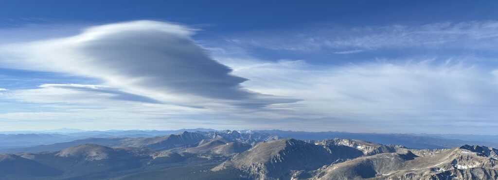

This picture is of stable formation that I think closely resembles a lenticular cloud formation. This is caused by laminar airflow over mountains and is indicated by its high formation and layers of smooth waves. This photo was taken on September 19th at 8:25am, from Longs peak facing west.
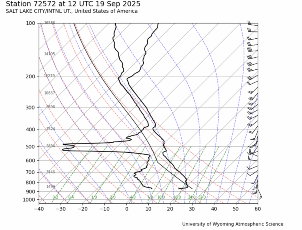
The skew-T shows a stable atmosphere overall, with airflow increasing with height. There is moist air lower down (around 500 mb) is likely where the cloud is just about to start and as air lifts into the stable layer (shown where temperature runs adiabatic) it condenses likely causing the lenticular cloud pictured above. The cloud likely starts to disappear around the 200mb as the temperature and dew point spread apart.
The Skew-T is from Salt lake because I felt this was a closer station to the cloud formation compared to Grand Junction.
Report:
Cloud Image Report: Lenticular Clouds over the Rocky Mountains

Nick Rhodes
Assignment: Cloud Image Report — Flow Visualization
Date: October 20, 2025
Image Date: September 19, 2025
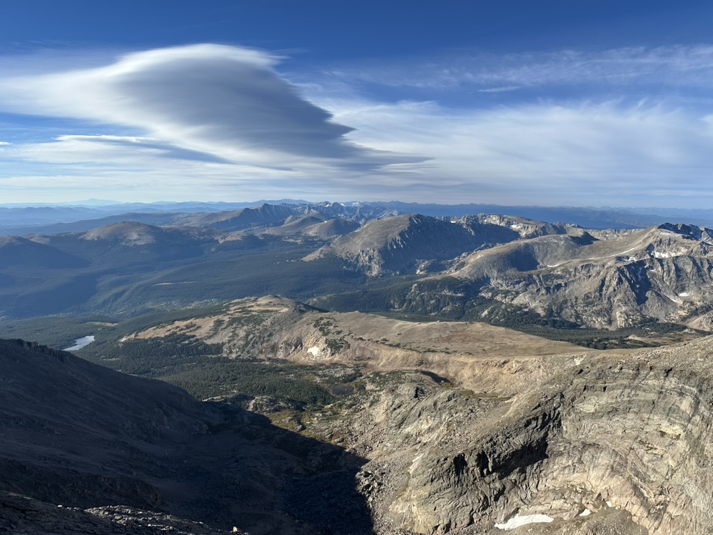
This image was captured on a hike up Longs peak which, at the time, was just to capture the scenery, shown in figure 3, but upon later review was an excellent cloud photo. A lenticular cloud produced by smooth airflow over the mountains is a great example to analyze the atmosphere stability that allowed its formation. The photograph was taken from the summit of Longs peak with views down the Front and Gore ranges.
-Circumstances of the Image:
Location: Longs Peak (~14,000ft)
Camera bearing: Facing southwest
Cloud Type: Lenticular cloud
Camera elevation angle: ~25° above horizontal.
Surface conditions: Cool, early-morning temperatures near freezing. Surface winds light to moderate.
-Cloud Identification
The primary feature is a Lenticular cloud formation [3]. This is caused by laminar airflow over mountains and is indicated by its high formation and layers of smooth waves. The cloud is stationary and shows smooth laminar layers throughout its height.
The Skew-T, shown in figure 1, is from station 72572 in Salt Lake City, shows a stable atmosphere overall, with airflow increasing with height. There is moist air lower down (around 500 mb) is likely where the cloud is just about to start and as air lifts into the stable layer (shown where temperature runs adiabatic) it condenses likely causing the lenticular cloud pictured above [2]. The cloud likely starts to disappear around the 200mb as the temperature and dew point spread apart.
-Visualization Technique
The cloud itself is the visualization of the airflow, the laminar flow can be seen in the smooth edges, and the condensation occurs where moist air hits cool atmosphere. Lighting was morning sunlight.
-Photography Technique
Camera: iPhone 14 Pro
Lens: Wide- 26 mm equivalen
Original image size: 4032 × 3024 px, final crop used 3032 × 1170 px t
Exposure: ~1/1900 s, f/1.5, ISO 32
Field of view: ~100°.
Post-processing: Cropping only
-Image Interpretation
The image demonstrates the physics of mountain waves [2]. The smooth lenticular formation shows where air passing through areas of most but stable air that is smoothly flowing across the mountain range. The thin trailing wisps along the edges suggests some minor vertical forces are at play. The cloud appeared to be stationary over the mountains, and is verified by the Skew-t due the moisture and temperature lines maintaining constant spacing through the area the cloud existed. Overall, this something that may go unnoticed but there is significant understanding to why and how something like this forms.
References:
1. University of Wyoming Atmospheric Science. Skew-T log-P diagrams archive. (Station 72572, 12 UTC 19 Sep 2025).
2. Stull, R. (2015). Meteorology for Scientists and Engineers, 3rd ed. Brooks/Cole.
3. UCAR Center for Science Education. “Lenticular Clouds and Mountain Waves.” Accessed 2025.
Figures:
Figure 1. Skew‑T diagram from station 72572, Salt Lake City, 12 UTC 19 Sep 2025
Figure 2. Final photograph (cropped).

Figure 3. Original photograph
1 Comment. Leave new
Really nice example of a lenticular. The smooth, layered structure is exactly what you’d expect from laminar flow over the terrain.