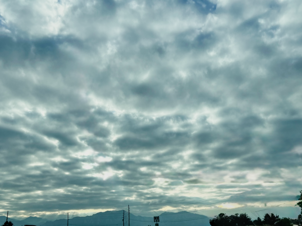
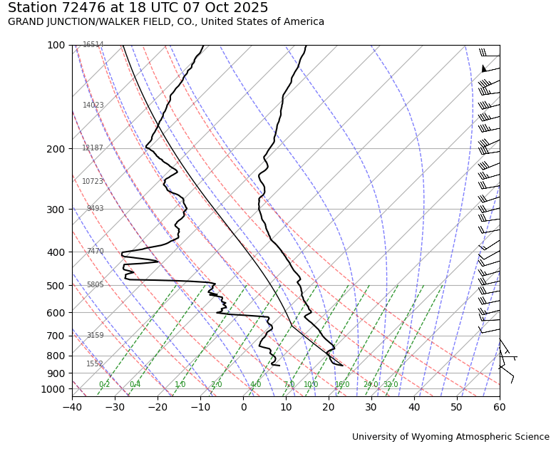
This photo was taken on 10/7/25 at 5:14 PM traveling westbound on South Boulder Road with an iPhone 14 camera. From the Skew-T diagram, it shows that the cloud shown is stable. The diagram shows that at 700 hectopascals the cloud level begins, and this is the lifting condensation level (LCL). The cloud shown is an altocumulus cloud with the sun behind it, illuminating the slight separation between each cloud. Altocumulus clouds form when the temperature of moist air drops, causing the air to condense. This can happen from warm air rising over the flatirons and then reaching lower temperatures and condensing.
Altocumulus Cloud Report
This is the first cloud image project, and the image was taken at 5:14 on 10/7/25 traveling westbound on South Boulder Road with an iPhone 14 camera. The cloud cover was stable and blocked the sky and it was an interesting image to capture. This image was captured while riding in the passenger seat of my friend’s car. The image shows an altocumulus cloud formation covering the sky east of the Rocky Mountains. It is backlit by the sun setting over the mountains.
This type of cloud forms when moist, warmer air drops in temperature, causing the air to condense. This altocumulus formation likely occurred as this moist, warm air rose up over the Rocky Mountains, cooled down from changes in altitude, and condensed. But this condensed air creates this blanket over the sky because of it was accompanied by a stable atmosphere. The Skew T diagram shows the air parcel (Middle line) lying between the dew point temperature and the temperature profile. This means the air parcel is cooling faster than the surrounding air, causing it to have reduced turbulence. This forms the stable blanket of clouds.
This visualization is condensed water vapor and the sun behind the condensed water vapor acts as a marked boundary. The lighting is due to the sun being further West than the clouds East of the Rockies. This type of lighting is continuous, bright sunshine. The sky looked homogeneously altocumulus type clouds. There was no front approaching. The clouds were not the same as the day before, they occurred and then disappeared. It did not remain that day, and there wasn’t high winds. The cloud heights appeared at 700 hectopascals.
The field of view is 54.3. The distance to the clouds is approximately 10,000 feet. The focal length of the image was 26mm . The camera was the iPhone 14 digital camera. The image is 4032 x 3024 pixels. The ISO was 50, f1.5, 1/3571. The final image was cropped horizontally, and the iPhone 16 “Cleanup” feature was used to remove a traffic light in the middle of the image.
The image is a great representation of the phenomena created in the atmosphere by living so close to a large mountain range. The image provides good information for the subject, the only issue is the image was taken quickly which resulted in the image being overexposed near the points of sunlight. In the future, I would have taken more time adjusting and reviewing the images to ensure it was properly exposed. I fulfilled my intent to capture clouds and the mountain range together. The physics are not represented very well in the image, but cloud science does enough to understand why the clouds formed the way that they did. To further improve this image, I would have taken it away from more of the inhabited area and gotten a clean image that didn’t need retouching.
References:
4 Comments. Leave new
Including the mountains in the background was a great choice — it really gives a good sense of height in the photo
I really like how this was edited. The contrast allows for an easier specification of cloud type.
Hi Kanon,
I think the teal-ish tint to this image is really interesting – there’s almost a haze in the atmosphere. Additionally, I like how you can see the rays of light shining through the clouds in the background near the mountains. Good work!
The lighting on this is very interesting with the sun behind the clouds, and I like the little peak of blue sky on the top right side.