
I believe this is altocumulus and stratocumulus at sunset. Conditionally unstable.
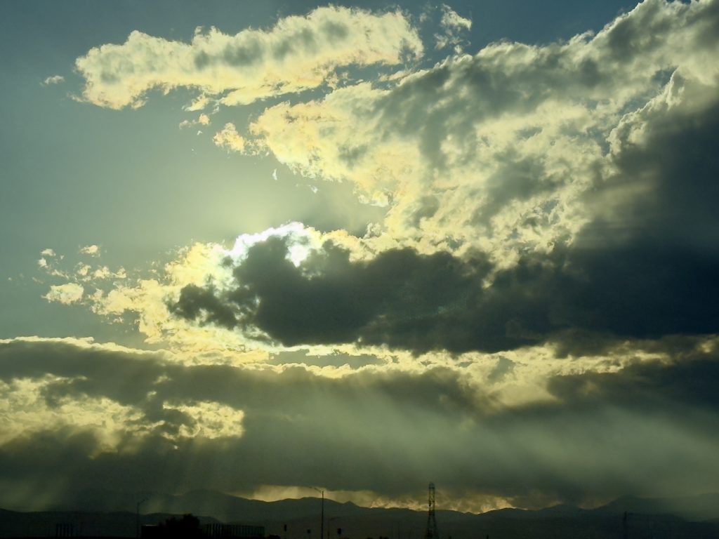
Altocumulus and Stratocumulus with Virga over the Front Range before Sunset
Evan Mason
Clouds First
MCEN 4151
Image taken October 12, 2026, 5:33 PM MDT, near Commerce City, Colorado
October 19, 2026
The purpose of this image was to capture layered clouds over the Front Range late in the day, when the low sun lights the edges of the clouds and shines through gaps between them. This was the Clouds First assignment, and I worked on it alone. I took the photo on October 12, 2026 at 5:33 PM MDT near Commerce City, Colorado, at an elevation of about 5,100 ft. I was facing west toward the foothills and the sun, with the camera tilted up about [fill in]° from horizontal, which was low in the west-southwest. The final image is shown in Figure 1.
Figure 1. Final image of altocumulus with virga and crepuscular rays over the Front Range, October 12, 2026, 5:33 PM MDT.
At the time, the sky had two main layers of clouds. The upper layer was made of bright, lumpy patches with yellow edges lit by the sun, spread across the top of the view. Below it was a darker, flatter layer that stretched across the whole frame, with gray streaks hanging down toward the mountains. Sunlight broke through gaps in the clouds, creating visible rays that fanned down to the ground. The photo was taken roughly an hour before sunset.
The weather consisted of scattered light rain storms coming down from the front range into the plains with mild wind.
The upper clouds are altocumulus, which are mid-level clouds. They appear as separate rounded patches instead of one smooth sheet, and they are made of small water droplets, which gives them sharp edges (Ahrens 2012). The lower deck is darker and more uniform, and I identified it as stratocumulus with virga. Virga is precipitation that falls out of the base of a cloud but evaporates before it reaches the ground, which shows up as the soft gray streaks below the deck (Ahrens 2012).
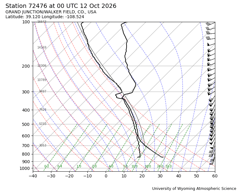
The atmospheric sounding used for this image is the University of Wyoming Skew-T for Grand Junction, CO at 00Z on October 13, 2026, shown in Figure 2. 00Z on October 13 is 6:00 PM MDT on October 12, which is 27 minutes after the photo was taken and is the closest launch time. Grand Junction is on the other side of the Continental Divide, so the sounding shows the air mass moving toward Denver from the west and not the exact air above the camera.
Figure 2. Skew-T diagram for station 72476 (Grand Junction, CO), 00Z October 13, 2026 (University of Wyoming).
On a Skew-T diagram, the right black line is the measured temperature, the left black line is the dewpoint, and the thin gray line is the path a parcel of surface air would follow if it were lifted. Where the temperature and dewpoint lines are close together, the air is close to saturated and clouds are likely (Wallace and Hobbs 2006). In this sounding, the two lines come closest between about 600 mb and 470 mb, where the dewpoint depression is only about 3 °C. From the heights printed on the diagram, 500 mb is at 5,719 m and 700 mb is at 3,065 m, which puts this moist layer at roughly 4.3 to 6.2 km above sea level. That is the height range for mid-level clouds and matches the altocumulus. Above about 430 mb the dewpoint drops off sharply to the left, so the air above the cloud layer was very dry. This dry air is why the clouds formed in a thin layer instead of one deep, thick cloud. The wind barbs on the right side of the diagram show westerly to southwesterly winds through the middle and upper levels, getting stronger with height and reaching 50 knots or more near 250 mb. These winds carried moisture from the west over the mountains toward Denver.
Near the ground, the temperature and dewpoint are about 5 °C apart. The lifting condensation level (LCL), the height where a rising parcel cools enough to saturate, can be estimated from the surface dewpoint depression (Ahrens 2012).
z_LCL ≈ (125 m/°C)(T − T_d) = (125 m/°C)(5 °C) ≈ 600 m above ground
Grand Junction is at about 1,475 m, so this puts the LCL near 2.1 km above sea level, which agrees with where the gray parcel line bends from the dry adiabat onto the moist adiabat at about 770 mb.
To decide whether the atmosphere was stable, I compared the parcel line to the temperature line. If a lifted parcel is warmer than the air around it, it keeps rising, and the atmosphere is unstable. If it is cooler, it sinks back and the atmosphere is stable (Wallace and Hobbs 2006). In this sounding the parcel line runs to the left of the temperature line from the LCL up through the cloud layer, and it stays to the left above about 450 mb. That means a lifted parcel is never meaningfully warmer than its surroundings, so there was little or no CAPE, and the atmosphere was stable. There is also a thin layer between about 790 and 740 mb where the temperature increases with height by about 2 °C over roughly 400 m. A temperature inversion like this is strongly stable and acts as a lid on air rising from the surface.
The visualization technique was natural light scattering by cloud droplets. Cloud droplets are around 10 µm across, which is much larger than the wavelength of visible light, so they scatter all colors about equally and clouds look white or gray instead of blue (Lynch and Livingston 2001). Because the sun was low in the sky, its light passed through a long path of atmosphere before reaching the clouds, and much of the blue light was scattered out along the way. This is why the cloud edges facing the sun look yellow, which I also strengthened in editing. The lower deck looks dark because it is thick enough that most of the light entering its top is scattered back out before reaching the bottom, and because I was looking at its shaded side. The rays below the clouds are crepuscular rays. They form when sunlight passes through gaps in the clouds and lights up haze and moisture in the air, while the cloud shadows leave dark lanes in between (Lynch and Livingston 2001). The rays are actually close to parallel, and they only appear to fan out because of perspective.
The photo was taken with an Apple iPhone 16 Pro using its main camera, which has a focal length of 6.76 mm, equal to about 24 mm on a full-frame camera. This gives a horizontal field of view of about 74°. The clouds were several kilometers above me and tens of kilometers away, so the image covers a large area of sky toward the foothills. The settings were f/1.78, a shutter speed of 1/6400 s, and ISO 64, with no flash. The very short shutter speed came from pointing the camera close to the sun, and it exposed for the bright cloud edges, which left the foreground as a dark silhouette. The original image is 4032 × 3024 pixels.
For editing the image was cropped and had slight adjustments to saturation and brilliance. The warmth of the image was increased to bring out a much warmer tone in the image. The original is slightly cooler and has a more blue tint. The original, unedited image is shown in Figure 3.
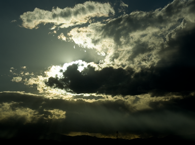
Figure 3. Original, unedited image.
The image shows two layers of cloud with the sun shining through the gaps, and rain falling from the lower layer toward the mountains. I like the contrast between the bright yellow edges of the altocumulus and the dark lower deck, and I like how the crepuscular rays and virga show light and water moving through the air under the clouds. The physics are shown well, since the flat, layered clouds and the virga match what the sounding shows: a stable atmosphere, a thin moist layer at mid levels, and dry air below and above it. What I dislike is the green color cast that came from warming the image in editing, which makes the sky look less natural, and the power lines and tower at the bottom of the frame, which distract from the clouds. Also, because the Grand Junction sounding is on the other side of the Continental Divide, it may not exactly match the air over Denver. I met my main intent of showing layered clouds and the low sun lighting them up. To improve the image, I would adjust the warmth more carefully to avoid the green cast, frame the shot to leave out the power lines, and compare it against the Denver sounding. A question I still have is whether the lower deck was being lifted by the foothills, since air flowing from the east toward the mountains is forced upward.
References
Ahrens, C. D. (2012). Meteorology Today: An Introduction to Weather, Climate, and the Environment, 10th ed. Brooks/Cole.
Lynch, D. K., and Livingston, W. (2001). Color and Light in Nature, 2nd ed. Cambridge University Press.
University of Wyoming Department of Atmospheric Science. Upper air soundings. weather.uwyo.edu/upperair/sounding.html
Wallace, J. M., and Hobbs, P. V. (2006). Atmospheric Science: An Introductory Survey, 2nd ed. Academic Press.

