Clouds 4: Clouds in Unstable Atmosphere

Figure 1: Cumulus clouds share a cloud base height – the lifted condensation level (LCL). Kalispell, MT, 4:14pm, September 7 2020, by Victoria Rios, Clouds First, 2020.

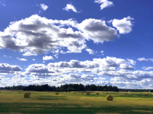
So now we know how to determine whether the atmosphere is stable or unstable. What does that tell us about the clouds? In an unstable atmosphere, localized variations in temperature will trigger rising air — thermals — over here and over there but not in between, so we will get clumps of cumulus clouds. There are many types of cumulus clouds, and they can form at any altitude, as discussed previously.  One aspect they share is flat bottoms, at least when they are formed in unstable air (cumulus can also sometimes form in stable air, as we’ll see later). As air is lifted and cooled, it will reach a height at which condensation begins: the lifting condensation level (LCL) , another index shown on the Skew-T diagram. This height is fairly uniform over a large area, resulting in a common cloud base height, as shown in Figure 1.

A young cumulus cloud formed by a vigorous thermal will often look like cauliflower, with crisp top and side edges as air rises inside the cloud and is then pushed out to the edges by more air coming up from below. This behavior is similar to any fluid jet plume .

Figure 2: Old and young cumulus clouds above the Indian Peaks Wilderness on 9/3/2022 at 4:42 PM, by Lucas Fesmire.

Small cumulus clouds are classified as cumulus humilis (very small, like in Figure 1)   or cumulus mediocris (medium-sized) . They typically last 10 to 15 minutes . Figure 2 shows both young and old cumulus clouds. Old clouds often have frayed or wispy edges, as the cloud sinks and evaporates. However, strong turbulence and wind shear can also cause frayed edges.

Figure 3: Cumulus castellanus below cirrostratus, near Curacao, Venezuela, April 5th 2014 , 1 pm. By Ryan Lumley, Clouds Second, Spring 2014

When the atmosphere is very unstable, with CAPE values of a few hundred to 1000 or more, cumulus clouds can grow rapidly, forming cumulus congestus , which includes cumulus castellanus or towering cumulus, as shown in Figure 3. This is a midway stage, before the cloud develops into a thunderstorm. When complete with rain, thunder and lightning, it has become a cumulonimbus , which typically reaches from low altitudes all the way to the top of the troposphere. At the top, the tropopause stabilizes the temperature profile, stopping further buoyant convection, forcing the cloud to spread out sideways, creating the classic ‘anvil’, or incus, shape.

Thunderstorms have spectacular fluid physics. A moist, unstable atmosphere, combined with wind shear can drive long lasting (hours long) storms that can cost billions of dollars in damages, as well as multiple human lives . Much is known about thunderstorm dynamics including how the ‘engine’ works: once the instability is triggered and air rises and condenses, the resulting cloud is still so unstable that the buoyant jet continues to accelerate upwards, entraining more air as it goes, resulting in huge quantities of kinetic energy in the moving air and pumping heat energy from the earth’s surface to outer space . Wind is an important ingredient too; the upper part of the cloud needs to be pushed out ahead (i.e. there has to be wind shear) so that the cold rain coming down the middle of the cloud doesn’t quench the updraft. Unfortunately, a full description of the dynamics and how they manifest in clouds is a bit beyond what I can discuss here. Instead, I invite you to learn from the many excellent videos of storms published by professional storm chasers who know enough about the behavior of storms and tornadoes to stay safe. One of my favorites is Mike Olbinski . In his Vorticity video series (e.g., Figure 4), the full range of storm-induced clouds are on display: pileus , mammatus , arcus , derecho , tornadoes , fractus , and more. They are well worth watching on a large, high resolution screen.
Figure 4: Compilation of thunderstorm time-lapse videos by Mike Olbinski


References

[1]
“Fractus cloud,” Wikipedia. Dec. 23, 2021 [Online]. Available: https://en.wikipedia.org/w/index.php?title=Fractus_cloud&oldid=1061672615. [Accessed: Mar. 02, 2023]
[1]
“Tornado,” Wikipedia. Feb. 19, 2023 [Online]. Available: https://en.wikipedia.org/w/index.php?title=Tornado&oldid=1140305788. [Accessed: Mar. 02, 2023]
[1]
Mike Olbinski, “Mike Olbinski .com.” [Online]. Available: https://www.mikeolbinski.com/. [Accessed: Mar. 02, 2023]
[1]
“Derecho,” Wikipedia. Jan. 28, 2023 [Online]. Available: https://en.wikipedia.org/w/index.php?title=Derecho&oldid=1136114561. [Accessed: Mar. 02, 2023]
[1]
“Arcus cloud,” Wikipedia. Jan. 26, 2023 [Online]. Available: https://en.wikipedia.org/w/index.php?title=Arcus_cloud&oldid=1135734155. [Accessed: Mar. 02, 2023]
[1]
“Mammatus cloud,” Wikipedia. Jan. 29, 2023 [Online]. Available: https://en.wikipedia.org/w/index.php?title=Mammatus_cloud&oldid=1136315281. [Accessed: Mar. 02, 2023]
[1]
“Pileus (meteorology),” Wikipedia. Mar. 10, 2022 [Online]. Available: https://en.wikipedia.org/w/index.php?title=Pileus_(meteorology)&oldid=1076357617. [Accessed: Mar. 02, 2023]
[1]
“Thunderstorm,” Wikipedia. Feb. 28, 2023 [Online]. Available: https://en.wikipedia.org/w/index.php?title=Thunderstorm&oldid=1142064051. [Accessed: Mar. 01, 2023]
[1]
K. Kiel, “August 2020 Derecho: A look back at the costliest thunderstorm disaster in US history,” https://www.kwqc.com. [Online]. Available: https://www.kwqc.com/2022/08/10/august-2020-derecho-look-back-costliest-thunderstorm-disaster-us-history/. [Accessed: Mar. 01, 2023]
[1]
“Cumulonimbus cloud,” Wikipedia. Dec. 09, 2022 [Online]. Available: https://en.wikipedia.org/w/index.php?title=Cumulonimbus_cloud&oldid=1126386334. [Accessed: Mar. 01, 2023]
[1]
“Cumulus humilis cloud,” Wikipedia. Jan. 04, 2023 [Online]. Available: https://en.wikipedia.org/w/index.php?title=Cumulus_humilis_cloud&oldid=1131540004. [Accessed: Mar. 01, 2023]
[1]
“Cumulus mediocris cloud,” Wikipedia. Mar. 30, 2022 [Online]. Available: https://en.wikipedia.org/w/index.php?title=Cumulus_mediocris_cloud&oldid=1080091850. [Accessed: Mar. 01, 2023]
[1]
“Cumulus Congestus cloud,” Wikipedia. Feb. 14, 2023 [Online]. Available: https://en.wikipedia.org/w/index.php?title=Cumulus_Congestus_cloud&oldid=1139391854. [Accessed: Mar. 01, 2023]
[1]
“Lifted condensation level,” Wikipedia. Dec. 24, 2021 [Online]. Available: https://en.wikipedia.org/w/index.php?title=Lifted_condensation_level&oldid=1061899791. [Accessed: Mar. 01, 2023]
[1]
GEORGE A. ISAAC, “Chapter 3. Summer Cumulus Cloud Lifetime - Importance to Static Mode Seeding,” in PRECIPITATION ENHANCEMENT - A SCIENTIFIC CHALLENGE, vol. 21, American Meteorological Society, 1986, pp. 25–28 [Online]. Available: https://link.springer.com/book/10.1007/978-1-935704-17-1
[1]
J. B. Klemp, “Dynamics of Tornadic Thunderstorms,” Annu. Rev. Fluid Mech., vol. 19, no. 1, pp. 369–402, 1987, doi: 10.1146/annurev.fl.19.010187.002101. [Online]. Available: https://www.annualreviews.org/doi/10.1146/annurev.fl.19.010187.002101. [Accessed: Feb. 17, 2023]
[1]
“Plume (fluid dynamics),” Wikipedia. Jan. 04, 2023 [Online]. Available: https://en.wikipedia.org/w/index.php?title=Plume_(fluid_dynamics)&oldid=1131598087. [Accessed: Feb. 02, 2023]
[1]
N. US Department of Commerce, “Severe Weather Topics.” [Online]. Available: https://www.weather.gov/ilx/swop-springtopics. [Accessed: Oct. 11, 2022]
Clouds 3: Skew – T and Instability
Clouds 5: Lift Mechanism 2 – Orographics